
Edge slow with big GPX files? Send a lighter course
Some route files carry a point every metre. Choose a lighter detail level when you send: a 240 km route goes from a minute to 6 seconds, rides the same, and the original is kept.
The route file for Saturday’s ride is enormous. Planners and recorded rides often put a point every metre or two, tens of thousands of them, most of which say nothing more than “the road carries on straight”. Sending that to a bike computer takes long, and your Edge has to carry all of it.
GPS on the bike is only accurate to about 3–5 m anyway. A point every metre doesn’t make the course any more precise; it just makes it heavier. Ridekit lets you send a lighter course that stays within a couple of metres of the original, and keeps the original on your phone.
What a lighter level does
A lighter level leaves out points close to the route line, height included. Where the road bends, the points stay. Where it runs straight, most of them go. The result is smaller and faster to send.
For example: a 240 km route with 47,000 points goes from a minute to 6 seconds at 2 m detail, and rides the same.
Choose a level
- Open the route and, under Tools, tap Send to bike computer.
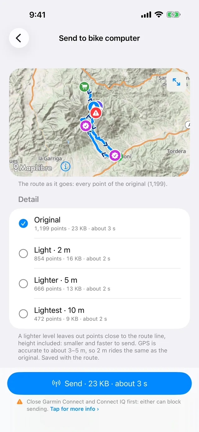
- Under Detail, pick a level. Each one shows how many points it keeps, the file size and about how long it takes to send:
- Original: every point of the route, unchanged.
- Light · 2 m: leaves out points within 2 m of the line (height too). Rides the same as the original, since GPS itself is only accurate to 3–5 m.
- Lighter · 5 m: smaller and faster; very tight turns are slightly smoothed.
- Lightest · 10 m: smallest; may cut tight switchbacks.
- Look at the map at the top: the original is in blue and your chosen level in orange over it. Zoom in to see where they differ, or tap ⤢ to compare the levels full screen.
- Tap Send.
The level you choose is saved with the route, so next time it goes the same way. On the Edge, a lighter course is named with its level in front, like “2m Mallorca 312”, so you can tell it apart under Navigation → Courses.
Let Ridekit suggest one
When a route is very detailed (more than 10,000 points, or points closer than 10 m apart on average) and you’re still on Original, Ridekit marks Light · 2 m as Recommended and says why: how many points instead of how many, and how long it takes to send instead. On the route page, the Send to bike computer row also says “Very detailed: 2 m recommended”.
For most big files, Light · 2 m is the one to pick. Go lighter only for very long routes on open roads, and check the switchbacks on the map first.
Your original is always kept
Choosing a level changes only what goes to the Edge. The route in your library, with all its points, stays as you imported it:
- You can switch back to Original at any time and send again.
- The route’s Share menu can still give you the Original file, exactly as it came in.
Sending several big routes
When you send several routes at once (tap Select in the library, or Send all… in a collection), the Detail choice applies to all of them: Own sends each at the level saved with it, or pick one level for the lot. The total size and time are shown before you send.
Very long routes: split them
A 600 km or 1,000 km route makes a big course even at a lighter level. With Pro or Plus you can split it into stages, at good stops or at the controls. Each part starts a little before the previous one ends, so the Edge picks up the next course right where you are. Combine that with a lighter level and every course is small and quick to send, even mid-ride.
Good to know
- Light doesn’t mean less accurate on the road. Within 2 m of the original is closer than GPS can tell. It’s still a normal Garmin course, with turn guidance and ClimbPro.
- Stops and points are kept. The points you send as course points (your points, stops you added, the route file’s waypoints) go along at any level.
- Faster sending helps most mid-ride. When plans change at a café, 6 seconds beats a minute. See change your route mid-ride.
- Detail levels are free, like sending.
- Not on an Edge? The FIT course export uses the detail level saved with the route too, so a Wahoo, Hammerhead or other bike computer gets the lighter file.
If sending is slow for another reason, like a Garmin app holding the Edge, see send a route to your Garmin Edge with no internet and the support page.