Riding into the night: controls, the Lock Screen and battery
Riding after dark, on a summer evening or an audax? Mark your controls, keep the ride on your Lock Screen, and get a warning before the last water and before dark.
It’s 300 km in and past midnight. The control closes in two hours, the last open café was at dusk, and your phone is at 40% in a back pocket. You don’t want to unlock it with cold fingers to find out how far the next water is. You want the bike computer to tell you about the control, and the phone to speak up only when it matters.
Your first ride past sunset may be much shorter than that, but the questions are the same: where’s the next water, when does it get dark, and how much is left. Here’s how to set Ridekit up for any ride that goes on after dark, from a summer evening that ran long to an audax, a 24-hour ride or an ultra.
Put your controls on your bike computer
The route file from the organiser may not mark the controls, or may mark them in a way your bike computer doesn’t show. Add them yourself:
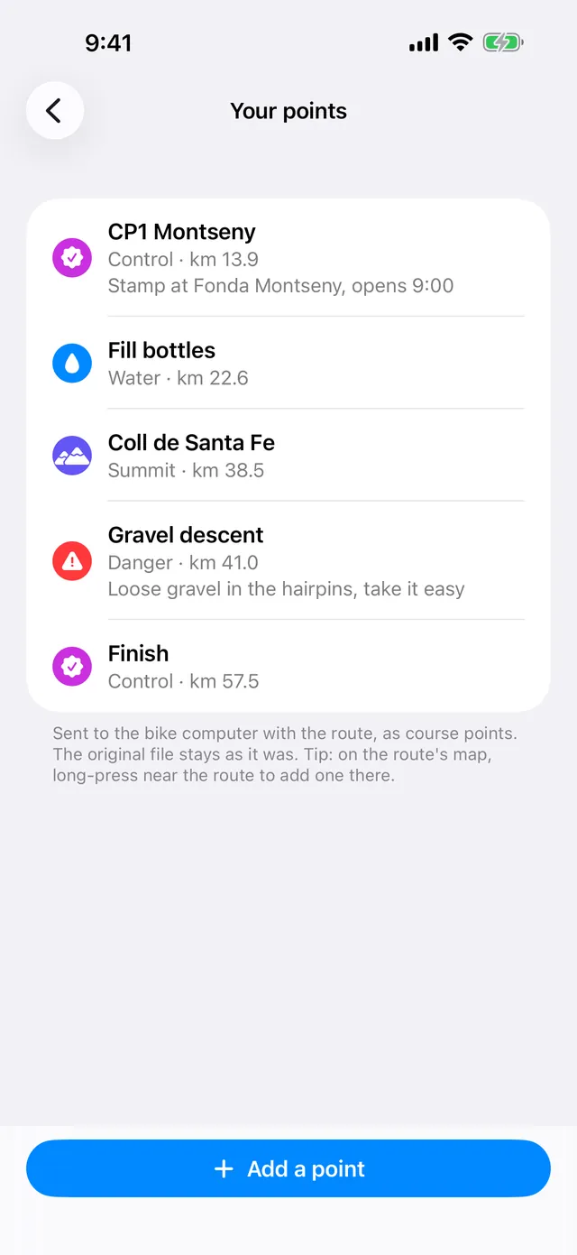
- On the route page, under Tools, tap Your points, then Add a point. Quicker: on the route’s map, long-press near the route.
- Choose Control, give it a name (“CP3 Boulangerie”), and place it: drag the pin or type the km. It snaps onto the route.
- Put the route on your bike computer. Your points go with it as course points: sent to a Garmin Edge they show under Up Ahead with their names, and in a FIT or GPX export (Export for your bike computer…) they go along in the file.
Control, Point and Danger are free. With Pro or Plus you get 17 more types (water, food, summit, steep climb, sharp bend, tunnel…), notes like opening times that you can read on the phone during the ride, and Private points that stay off routes you share with others. A Garmin Edge shows only the first 15 bytes of a name, and Ridekit shows you what fits as you type.
Your points are kept with the route and sync with iCloud. The original file stays as it was.
Know where the food and water run out
Before the ride, find the Stops along the way and look at the gaps: “No water for 42 km”, “No food for 65 km”. At night those stretches feel longer. The stop list marks places open 24/7: after dark, those are the ones that count. More in water and food along the way.
For a really long ride, split it at the controls: Split into stages → Controls (Pro or Plus) cuts the route at each control point. See a multi-day tour, stage by stage.
Your ride on the Lock Screen
Tap Start riding and Ridekit asks once: Ride on your Lock Screen? It’s off unless you turn it on. Tap Show my ride on the Lock Screen (or later, Settings → Ride on the Lock Screen).
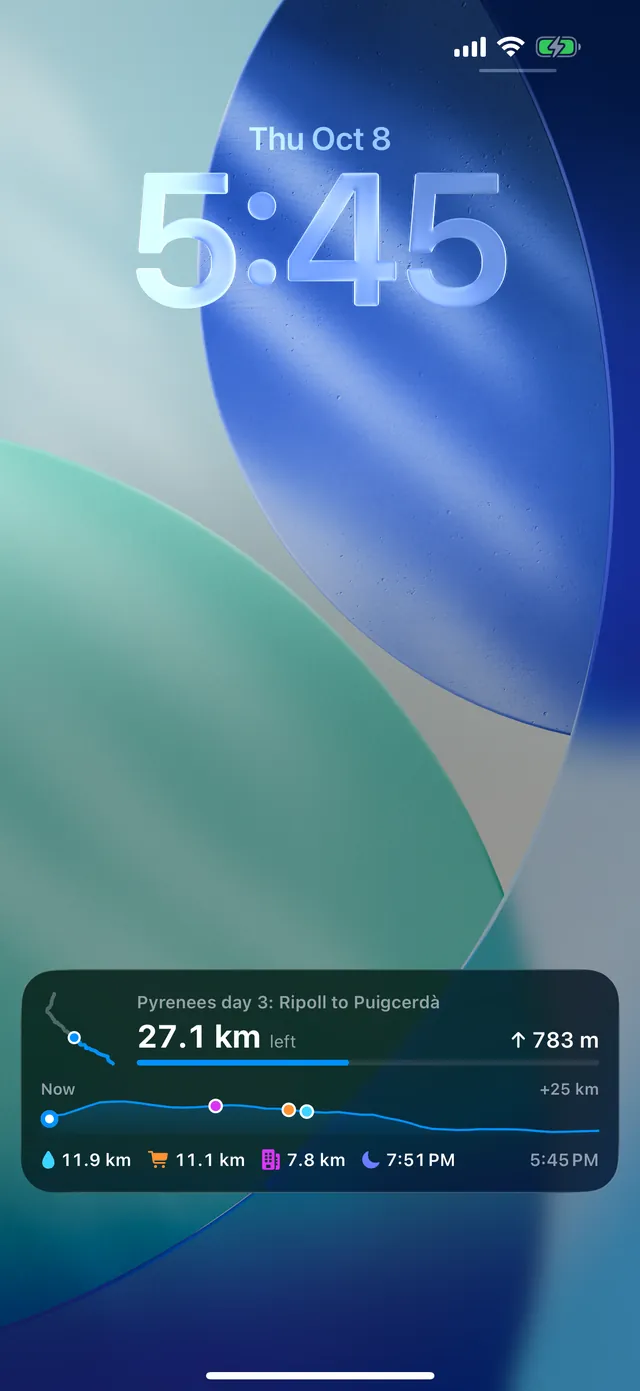
The Lock Screen, and the Dynamic Island, then show the route’s shape with you on it, km done and left, climbing left, the next 25 km of elevation with the next water, food and bed placed on it, and when it gets dark. One glance, no unlocking. It ends when you finish the ride.
Choose how it keeps up, and what it costs in battery
Under Keeping up while the phone is in your pocket, pick one:
- Checkpoints (recommended): no GPS running in the background. iOS wakes Ridekit near a few points ahead (the next stops, your bed, every 10 km) to update. Almost no battery. Needs location access set to Always.
- Live: low-power GPS in the background, about every 250 m, so the numbers follow you. Uses more battery: a few percent an hour, which adds up on a long ride.
- Only when I open Ridekit: no location in the background. The Lock Screen shows where you were when you last opened Ridekit. No extra battery.
On a 600 km ride, Checkpoints is the one to start with. For a busy stretch, say a town with several turns and stops, the ride’s Where you are card has a Live updates switch: the Lock Screen follows you every 250 m whatever your usual choice. Turn it off after the stretch (it also ends with the ride).
iOS takes a Live Activity off the Lock Screen after 8 hours. Ridekit tells you when that happens; open Ridekit and it’s back.
Two alerts worth waking up for
With the ride on the Lock Screen you can have two banners, each of which you can turn off:
- Last food or water before a long stretch: a few km before the last food with 40 km or more without after it, or the last water with 25 km or more without. For example “Last water for 38 km”, with the name of the place and how far it is.
- Darkness coming (45 minutes before): 45 minutes before it gets dark where you’ll be, with roughly how much is left to ride then. Time to put the lights on and the gilet in reach.
Each comes once a ride, never two within half an hour. Food and water are the kinds Stops along the way shows on your plan.
At night on the phone
- The Dark map style is easier on the eyes at night, and it’s free, offline too.
- With Plus or the Weather add-on, the weather on the route page says where it gets dark (“Dark from km 180”) and where rain gets likely. See weather along your ride.
- Find a bed, in the ride’s ⋯ menu, is there if you decide to stop for a few hours’ sleep. See find a bed on tour.
Good to know
- Everything here works with no signal, once the route is ready: the Lock Screen, the alerts and the stops are worked out on the phone.
- Sending a new course to a Garmin Edge mid-ride needs no internet either. See change your route mid-ride.
- If Checkpoints doesn’t keep up, check that location for Ridekit is set to Always in iOS Settings. Until then the Lock Screen updates only when you open Ridekit.
More on the support page.